 How can a historian cope with all invitations to look at celebrations and centenary events? On this blog you will expect me to present a different look at such events. Last year the celebrations of 200 years Kingdom of The Netherlands started, and I did write here about the opening activities and a number of portals and websites launched for this occasion. These festivities come now to an end, and one particular aspect offers itself for attention in a posting.
One of the newly founded institutions in the new kingdom was the Kadaster, the land registry office. This week the modern Dutch land registry office launched an educational website called Tijdreis over 200 jaar topografie [Time travel through 200 years topography]. Lately I noticed some online projects concerning Dutch historical cartography and topography which deserve the attention of legal historians and others interested in Dutch history, too. This theme gives me also the chance to look in a second section at other projects with digitized Dutch maps and atlases. In the third and last section of this contribution I will look closer at a recent overview of Dutch digitization projects. I have created a PDF with a list of the most important links in this post.
Travelling in time and space

Bilingual – Dutch and French – map, 1810 – source: Kadaster
The special website of the Kadaster succeeds in bringing something you might think existed already, but in fact it did not, although we will meet a slightly comparable project. On this interactive website you can start a time loop for the period 1815-2015 using the scale in the left sidebar, and view for every year – at least when available – a different map. You can stop the loop to contemplate the map in a particular year. Interestingly you can put in the name of a location in a free text search field, choose from the suggestions popping up or proceed with your own choice. You will end with a zoomed-in view of a particular place and zoom out at will.
While admiring this new digital tool it does not bring you quite what you expect from a land registry office. The educational website shows mostly regular topographical maps, and only when zooming in you can see maps with cadastral information. Of course one has to reckon with the production time itself of the first cadastral maps. The first map on the special website stems not from 1815, but shows the French départements with postal routes on a bilingual map created in 1810. The southern part of the later province Limburg is not included. As for 200 years Dutch land registry office, it was emperor Napoleon who decided in 1811 that this institution should come into existence. Only in 1816 work was resumed, and in 1832 54 offices of the land registry service were opened. Most of the first cadastral maps were created between 1812 and 1832. When the results of both cadastral and topographical maps became available some outstanding maps were created for wider use.
Combining geography, history and maps

The thought of putting historical information into a kind of GIS (Geographical Information System) is already some decades old. The last years convincing results of so-called HISGIS websites start to appear, often after promising beginnings, pitfalls, breakdowns and new design, both in terms of layout and technology. Perhaps closest to the idea behind the bicentennial map site of the Kadaster is the Dutch portal WatWasWaar [What Was Where] with a Dutch interface and an introduction in English. This portal offers you access to modern topographical maps with an overlapping layer with (links to) historical information and in particular other maps. You can set this website to show both a modern map and the pointers to historical information or show just one of these possibilities. I took the municipality Doorn in the province Utrecht as an example: you will find a number of cadastral, topographical and military maps, scans of the cadastral register (aanwijzende tafel), census information and even a nineteenth-century drawing of the manor Huis Doorn, from 1920 onwards the last domicile of the exiled German emperor Wilhelm II. In particular having access to the original cadastral maps at your screen is a great asset, and it is possible to filter for particular information and periods. There are also scans from map books for the region around Delft, Gelderland (Guelders) and Utrecht which bring you some locations in even greater detail.

More tuned to the needs of historians is the Dutch HISGIS portal. The portal started with a HISGIS for Friesland (Frisia), supported by the Fryske Akademy at Leeuwarden. Its regional background shines through in the absence of three Dutch provinces, North-Holland, Zeeland and Brabant. The modern province Flevoland is not even mentioned. However, you can find nationwide information about municipalities by clicking on the Nederland tab. For Brabant a pilot project has started with one municipality, Loon op Zand, a location famous for Europe’s largest area with moving sands and dunes, the Loonse en Drunense Duinen. A bonus are the sections for Amsterdam and Rotterdam, and even for Antwerp.
Reading the instructions (Uitleg) carefully is really necessary for this portal, for otherwise you would miss a lot on it. Although I have visited this HISGIS portal on earlier occasions I still find it not easy to get hold of specific information, but with due patience you can retrieve here much information. The quality of information depends also on the province of your research. For example, for the province of Utrecht you can look also at sketch maps (schetskaarten) showing the borders of each municipality; these documents, too, have been authenticated at the start of the process to chart all plots.
You must forgive me for mentioning here the great interactive map of the city of Utrecht created by Het Utrechts Archief, with not just historical locations and buildings shown on a modern map, but also access to older maps, images and much more. It really amounts to a HISGIS for the history of this city. The Drents Archief in Assen contributes map to AnnoDrentheNu, a website and an app enabling you to look at and walk using also historical maps.
Here are lions!

Dutch municipalities are the subject of two related projects dealing with the history of towns and villages. Their borders have changed very much since the early nineteenth century, but there is another problem as well. Some names of locations are not unique. Even within a small country like the Netherlands some locations share names. An example: I thought Oosterend, “East End”, was only a village on the Frisian isle Terschelling, but there is another one as well. In Frisian, the second official language in my country, Easterein is now in Littenseradeel near Franeker, Aasterein is the Frisian name for the location on Terschelling,, and thus you can distinguish them. At Gemeentegeschiedenis [Municipal history] you can find the names of the 1100 municipalities existing in 1812 and all their successors up to the modern situation with just over 400 Dutch municipalities. You can search also for official place-names in the départements during the French occupation under Napoleon.
A second website, Histopo, also created by the team of Hic Sunt Leones [Here are lions] goes one step further and gives access to some 27,000 historical names of locations, hamlets, villages and cities. Apart from a repertory of municipalities since 1812 the creators acknowledge the use of two valuable sources which you would not immediately come up with. Nineteenth-century militieregisters (military draft registers) contain place names in many variant spelling, duly noted by the city archives in Amsterdam and put into two data sets. Another project at Amsterdam dealing with ondertrouwregisters, registers for the publishing of banns for couples wanting to marry, gives us place-names in sources from the seventeenth and eighteenth century. The national crowdsourcing palaeographic project Vele Handen [Many Hands] deals with both the militieregisters on a nationwide basis, kept between 1811 and 1941, and the ondertrouwregisters between 1602 and 1811.
A third project of Hic Sunt Leones focuses on the historical names of streets in Amsterdam. Combining maps with all kind of data sets is the heart of each project featured here. Yet another Dutch website covers roughly the same subject, ErfGeo, with here, too, among the people in the project team members of Hic Sunt Leones. Here you can search for names of locations, and also for streets and even for buildings. My mother lived twelve years in Zwolle, and she remembered wondering about the Korte Ademhalingssteeg, “Short Breath Alley”, in Zwolle an alley once close to the scaffold at the main market place. ErfGeo can lead you to places no longer existin and show you the growth of cities based on the Atlas van de verstedelijking. It is even possible to ask for the nicknames of Dutch locations during Carnival! For the geographical information on your screen for a particular location these projects are not solely focusing on the Netherlands. The Getty Thesaurus of Geographic Names can be tuned to work with data sets using the special Getty Vocabularies portal.
Hic Sunt Leones, “here are lions” is the phrase used by early cartographers to indicate zones later termed terra incognita. Lately the use of this phrase and its actual presence on medieval and sixteenth-century maps has been questioned. A few weeks ago a news item described the discovery on the so-called 1491 Martellus Map at Yale’s Beinecke Rare Book and Manuscript Library of among other texts a longer phrase with the words in quibus leones, “where are lions”. Multispectral imaging enhanced the faded colours and texts at this map and reinforced its brightness and legibility.
As for more HISGIS projects the links section of the British Historical GIS Research Network, HGIS-Germany and HGIS Links (Jessica DeWitt, University of Saskatchewan) are good starting points. The idea of a HISGIS has also lead to several projects using maps within the humanities, ranging from Early Modern London and Locating London’s Past using John Rocque’s map from 1746 to the interactive maps of Regnum Francorum Online, a project of Johan Åhlfeldt, the Pleiades gazetteer of the ancient world and Stanford’s delightful ORBIS for travelling in Classical Antiquity. Earlier this year I discussed the Landesgeschichtliches Informationssystem Hessen (LAGIS), created by the Hessisches Landesamt für geschichtliche Landeskunde and the Universität Marburg.
The Low Countries and digitized old maps
It is a joy to write here about historical maps from the Low Countries. Faithful visitors of my blog will perhaps remember how I adduced the beautiful sixteenth-century town maps created by Jacob van Deventer in postings about a number of small Dutch towns. In its links section WatWasWaar points to a number of interesting projects with historical maps. As a finale to this post I will briefly list a number of projects. Even if some information might already be given here in earlier postings I like to bring them together here.

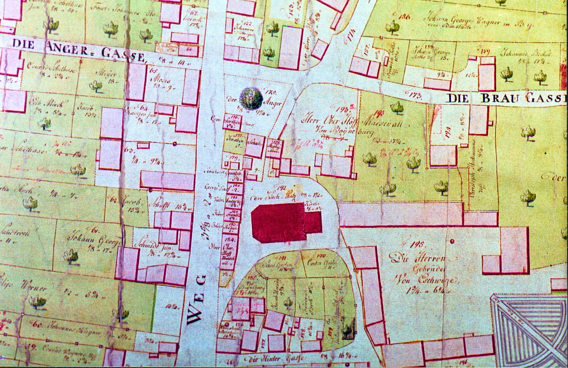
Map of Zwolle by Jacob van Deventer (detail) – Madrid, Biblioteca Nacional de España
Jacob van Deventer (around 1500-1575) had been charged in 1558 by the Spanish king Philipp II with a large-scale cartographical project, the making of topographical and bird-view maps of the Low Countries. The surviving maps, the first set of reliable town maps for this region of Europe, have been digitized in the Biblioteca Digital Hispánica of the Biblioteca Nacional de España in Madrid.
While preparing this post I noticed the link to a digital version of the famous seventeenth-century atlas created by Willem Blaeu at the website of the Regional Archives in Leiden. There is at least one other digital version of this atlas, using the copy in the library of the Illustre Collegi d’Avocats de Barcelona. This college, too, has digitized its Atles Blaviana, the Atlas Major of Joan Blaeu (11 vol., Amsterdam 1662), accessible at the Memòria de Catalunya portal for the cultural heritage of Catalonia. This portal in its turn helped me not to forget to mention the Dutch portal Memory of the Netherlands, with among the 133 digital collections the Atlantic World project of the Dutch Royal Library and the British Library containing a substantial number of old maps. The Royal Library contributes the Atlas Van der Hagen (around 1690) and the Atlas Beudeker (around 1750) with not only maps, but also topographical prints and drawings. The 2,600 drawings and prints of hamlets, villages and towns in the Atlas Schoemaker, also held at the Royal Library in The Hague, can give you vivid images of buildings and people in the Dutch Republic during the eighteenth century. In fact the word atlas in Dutch cultural institution can mean both an atlas with maps and a topographical-historical collection, for example the Atlas van Stolk in Rotterdam with many thousands digitized drawing and prints.
On using a new overview of Dutch digital projects
My last paragraph with its seemingly erratic stepping-stones might seem a personal whim, but I steered it on purpose to a project at the Royal Library. On September 10, 2015, I ended my post about Dutch pocket law books with a remark about a recently completed survey of Dutch libraries and their digitization projects. To my disbelief the final report Bibliotheekcollecties in het netwerk [Library collections in the network] published online by the Royal Library does not give you in the overview of actual projects the exact web addresses. Add to this hiding the link at their website to a version of the overview with URL’s included, and you might guess my misgivings. The Royal Library did send me in August a new version of this list, and for your convenience I have uploaded it here. It seems worthwhile to look at this overview and to check for digitized historical maps. If such a survey serves any scholarly purpose it should be that of a concise practical guide with sufficient indications of the scope and contents of collections.
The overview covers 514 collections and gives succinct information in tabular format. At Leeuwarden Tresoar, the combined Frisian regional archives and Provincial Library, have digitized a number of atlases, and there is a pilot for a new digital map collection with for now just five maps. A search for kaarten (maps) at this new portal learned me quickly to prefer the advanced search and filter for the document-type maps, because kaart in Dutch is also used for postcards… The Vrije Universiteit (VU) in Amsterdam is said to digitize landgoedkaarten (manor maps), but no link is provided; the collection is to be found within the general digital image database at the VU. Interestingly the VU has created the portal VU Geoplaza for modern GIS maps. The link to the nearly 800 digitized maps of the university library in Groningen did contain a typing error. Overijssel in kaart is a portal for digitized maps from four collections in the province Overijssel. Probably the best known Dutch digital map collection is the one held by the university library at Amsterdam with 450 digitized maps which includes the collection of the Royal Dutch Geographic Society, In view of the sheer number of atlases and maps the selection is rather small, but really important. There is a section with seven city atlases covering not only the Low Countries, but even cities all over the world in Jansonius’ work Theatrum urbium (….) (Amsterdam 1657).

The next link to a digital map collection in Amsterdam is unfortunately broken, but triggered my attention for atlases. Is there indeed no functioning digital version of the famous Atlas der Neederlanden, nine volumes containing rare maps made between 1600 and 1800? A quick search learned me that there is a selection of maps accompanying the project for a facsimile edition of this atlas published in 2013. The list fails to indicate for Amsterdam the presence of digitized maps in the Suriname collection 1599-1975, Of course the quality of the information in this survey led by the Royal Library depends to some extent on the information provided by the institutions organizing projects for digital maps, but it seems little checking and updating has been done, nor is there a good explanation for the many collections without any indication of a URL. I cannot help noting these defects for a library which can boast a major role in many international projects bringing it justifiably great prestige.
We had better look at the collections indicated in the list and find the working web addresses ourselves, and thus I did. The digital map collection of the Royal Tropical Institute is now managed by Leiden University. The list duly notes that a large number of these maps – in fact some 7,100 – can also be reached in the image database of this research institute. In its digital collection Alterra maps Wageningen University shows maps made in the twentieth century dealing with the physical geography of the Netherlands. For Wageningen this list points to the filter for maps in the library catalogue at Wageningen University, but except in a few cases not to digital maps. Conspicuously absent in the list is the university library in Utrecht. There used to be a separate subdomain for digitized maps, but now you can at least find them using the advanced search mode of the library catalogue and check for digital availability. The special collections in Utrecht have great holdings in map collections which can be searched on collection level in a useful repertory.
Anyone vaguely aware of the history of Dutch cartography knows there is much more to be found, and of course an updated overview – only in Dutch – can be found online at the website of the scholarly journal Caert-Tresoor (old Dutch for Treasury of Maps). Between 2005 and 2010 a number of online map collections has been presented in the section @ la Carte. A quick look at this website gives you digital maps at the regional archives in Groningen, typically missed in the overview where at least a number of libraries at regional archives have been included, but for example the Gelders Archief in Arnhem and its maps do not appear at all. The Beeldbank of the Technical University Delft is mentioned, but there is no indication of its contents, though this image database does contribute to WatWasWaar. Has the Royal Library by any chance been misled by the lack of maps in the project database at the portal Kenniscentrum Digitaal Erfgoed Nederland [Knowledge Center Digital Dutch Heritage]? Filtering for cartographical materials offers you some forty digital projects, but alas only a few of the projects presented here show up. To be honest, maps are often included indistinctly within these projects.
This post shares a defect with a number of earlier postings, my clear wish to include many things within the compass of one post! I leave it to you to check the PDF of the list for your own research and to add map projects from the descriptions at Caert-Tresoor. At the national level it is justifiable to mention the digital maps of the Nationaal Archief, and to point to the maps dealing with a much wider territory at the digital portal Atlas of Mutual Heritage, an interactive map accessible in Dutch and English leading you to many objects and bibliographical information, with for example another atlas by Blaeu – held at the Österreichische Nationalbibliothek in Vienna – and many rare maps concerning Dutch colonial history, worldwide trade and the history of the Dutch India Companies.
Uncharted digital territories
You might search for the right words doing justice to this kind of overviews, but I had rather use my time and energy to create an overview tailored to my specific need of knowing about a particular type of document within Dutch digital collections. When I could not find any reliable list of digitized pamphlets apart from the seventeenth-century mazarinades I started creating it myself. Surveying the holdings of cultural institutions has successfully been done at the collection level for Dutch museums which led to the creation of a number of regional websites for cultural heritage, often with the word Erfgoedhuis in its name, and in some cases to regional portals for digitized cultural heritage. In my country some themes and subjects are well served indeed with national digital platforms for materials concerning maritime history (Maritiem Digitaal), etnographic collections (Stichting Volkenkundige Collectie Nederland), university collections (Academische collecties), medical collections (Medisch Erfgoed), and also military history (Militair Erfgoed).
There are several gaps and weaknesses in the overview supplied by the Royal Library, with even no changes and corrections between the version of May 2015 and the latest one. Its lack of order is just another characteristic. However, you have to appreciate some dificulties in creating any consistent overview. Should one skip the libraries of archival centers? Should one create separate entries for each document type in a digital collection, or list them in a separate field for each entry? The list contains a number of abbreviations to indicate the presence of meta-data and physical objects, but they have not been used consistently. Strange is the exclusion of the Royal Library’s own digital collections, including the Delpher portal. The editors have listed some digital collections of the International Institute for Social History in Amsterdam, but they skipped its collections at the Social History Portal.
It would certainly make a difference if we could access such information in an online database. The very creation of a database would demand solid thinking about the things to include or exclude, and above all concern about reliable input and maintenance. I am sure the Dutch Royal Library is capable of doing this. In fact the Metamorfoze website of the Royal Library offers already a succinct overview of Dutch digital projects which received financial support from the Dutch government. Out of sheer curiosity I looked for any project with maps, and I found the Bunkerarchief, a project at the Nationaal Archief concerning Dutch military defense with scans of some 9,000 maps and drawings made in the twentieth century. Luckily the online inventories of archival collections at the Dutch National Archives do tell you about the presence of scans of materials, but this large collection merits special mention in their research guide for maps and drawings. Here, too, a translation into English of the website or at least useful summaries would be most welcome.
Locating valuable digital collections can be a daunting task. In a digital world you still need reliable guides to information if you have to know more than the ever active global web company and its famous search engine brings you. I should have made a screen print of its name which showed at its start screen this weekend a heart with the Dutch national colours and a crown to honour the festivities celebrating the Kingdom of the Netherlands! You have read here the names of many libraries and archives, but museums, too, have maps in their holdings. Maps help us to realize that historical events and developments took place in particular surroundings, sometimes barely charted, sometimes mapped again and again to inform and please people. Maps help us to chart the past and to discern the variety of perspectives, limits and borders seen, perceived and created by people living in past centuries.
These days you cannot escape from seeing the grim reality of borders, and I feel awkward not to mention here this fact. We cannot be strangers to current events. VU GeoPlaza has in its links section a link to another VU project, Death at the Borders, showing one dot for each dead migrant on his or her way to Western Europe from 1999 until the end of 2013. An interactive map of the Mediterranean shows regions scarcely seen in the main media. Current figures about migrants going to Europe can be found at the online map of the Missing Migrants Project of the International Organization for Migration in Geneva.
A postscript

While musing over my experiences in tracing digitized old Dutch maps it crossed my mind to use the Archiefzoeker, the inexhaustible concise guide in Dutch to digital collections all over the world. Eric Hennekam, its indefatigable creator, has put together nearly 5,500 collections. He announces new additions often at Twitter (@erichennekam) or at his blog Point de vue. I immediately found a recent posting about the mobile app of Old Maps Online, a marvellous portal where you can also find digitized maps held at the Dutch National Archives and Utrecht University Library.
Searching with precise search terms can yield much here, but for maps and atlases there is in the Dutch language a particular problem. When looking for the Dutch word kaart the nearly eighty results contain not only maps, but also gezinskaarten and persoonskaarten, family files and personal files in population registers, and prentbriefkaarten, postcards. Even the words kaartenbak, card file, and inspectiekaart appear, the latter for an inspection map of the Dutch Food Authority. Using the word atlas brings you also to a morphological atlas and an atlas of Dutch literary authors. The atlases with maps within The Memory of the Netherlands are not yet included, but some topographical atlases are present.
For more precise results tagging and classifying entries is sorely needed, because it is now rather cumbersome to find the things you are really looking for. Creating a mass of information should be followed by clear cataloguing in order to make the information useful and to ensure clear search results. Any grumblings over broken links, incomplete information or silly mistakes are another matter: constructive comments and contributions are most welcome…
In a post with a large quantity of web links inevitably sites disappear or links are broken. Unfortunately the very helpful portal Wat Was Waar has been taken down in January 2016. You can view the cadastral information in the image database of the RCE, other datasets are still waiting for a new appearance.
Old maps in Belgium
At the Cartesius portal you can view digitized old maps of the Low Countries from the holdings of a number of Belgian instutions. The Studiekring Historische Cartografie has another useful selection of digital map collections.